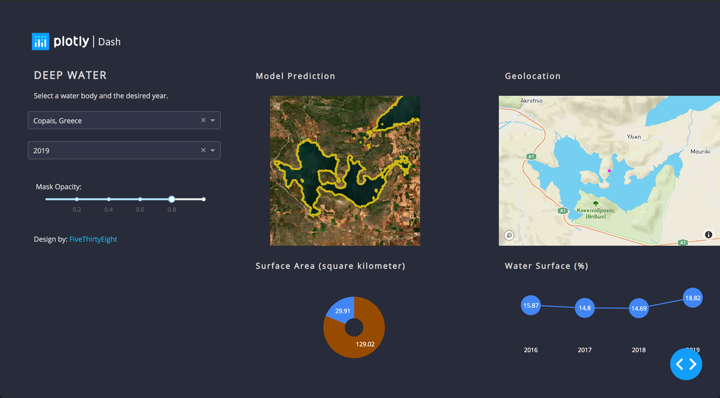
Track the evolution of water in the great lakes of the world.

Through a wide variety of mobile applications, we’ve developed a unique visual system and strategy that can be applied across the spectrum of available applications.

Overview: I worked on a project focused on water body segmentation using advanced machine learning techniques. The project involved collecting and processing satellite imagery data, applying segmentation algorithms, and visualizing the results to make them accessible and understandable to stakeholders.

Key Contributions:

  1. Data Collection:

    • Datasets: Collected satellite imagery and other waterbody data using the Sentinel Hub dataset and the Resisc45 dataset.
    • Manual Labeling: Manually labeled the data using an online tool, preparing it for subsequent analysis and training.
  2. Data Preprocessing:

    • Cleaning and Preparation: Preprocessed the collected data to ensure it was clean and suitable for machine learning applications. This included normalizing images and addressing any inconsistencies in the data.
  3. Machine Learning Techniques:

    • Model Implementation: Applied machine learning techniques such as U-net and Residual U-net for water body segmentation. These models were chosen for their effectiveness in image segmentation tasks, particularly in distinguishing water bodies from other land features.
  4. Visualization and Analysis:

    • Dash Framework: Used the Dash framework to create visualization and analysis tools. These tools made the data and segmentation results accessible and understandable to stakeholders, facilitating informed decision-making.
    • Interactive Dashboards: Developed interactive dashboards that provided clear and actionable insights, allowing stakeholders to explore the segmented data visually.

Impact: This project demonstrates my ability to handle end-to-end machine learning workflows, from data collection and preprocessing to model implementation and result visualization. By making complex segmentation results accessible to stakeholders through intuitive dashboards, the project highlights my proficiency in both technical and communication skills, ensuring that the insights derived from the data can be effectively utilized.

Including this project in your portfolio showcases your expertise in remote sensing, image segmentation, and data visualization. It emphasizes your capability to leverage advanced machine learning techniques to address real-world challenges, transforming raw data into valuable and actionable insights.